Aerial Survey Services Market Size, Share, Trends, Growth 2034

Aerial Survey Services Market By Services (Photogrammetry, LiDAR, Thermal imaging, Multispectral imaging, and Others), By Platform (Fixed-Wing Aircraft, Rotary-Wing Aircraft (Helicopters), and Unmanned Aerial Vehicles (UAVs/Drones)), By Application (Aerial Photography and Remote Sensing, Data Acquisition and Analytics, Mapping & Surveying, 3D Modelling, Disaster Risk Management and Mitigation, and Others), By End-User (Government and Defense, Oil and Gas, Mining and Minerals, Agriculture, Forestry, and Others), and By Region - Global and Regional Industry Overview, Market Intelligence, Comprehensive Analysis, Historical Data, and Forecasts 2025 - 2034
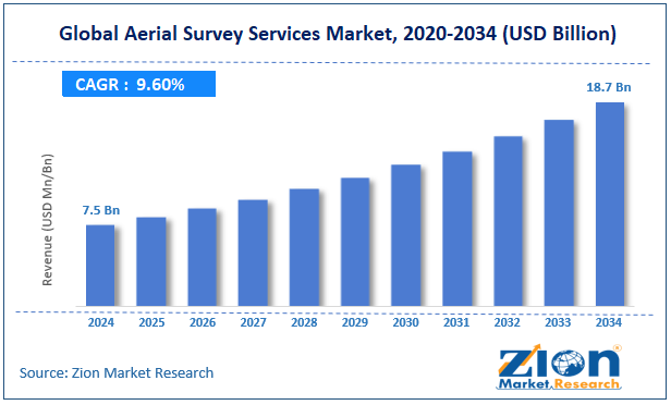
| Market Size in 2024 | Market Forecast in 2034 | CAGR (in %) | Base Year |
|---|---|---|---|
| USD 7.5 Billion | USD 18.7 Billion | 9.6% | 2024 |
Aerial Survey Services Industry Prospective:
The global aerial survey services market size was worth around USD 7.5 billion in 2024 and is predicted to grow to around USD 18.7 billion by 2034, with a compound annual growth rate (CAGR) of roughly 9.6% between 2025 and 2034.
Aerial Survey Services Market: Overview
Using aircraft, helicopters, unmanned aerial vehicles, balloons, or other aerial techniques, aerial surveys are a way to gather geomatics or other imagery data.
Aerial photography, Lidar, remote sensing (using numerous visible and invisible electromagnetic spectrum bands, such as infrared, gamma, or ultraviolet), and geophysical data (such as aeromagnetic surveys and gravity measurements) are examples of common data collection methods. A map or chart created by examining a region from the air can also be referred to by this term.
Because aerial survey has superior quality, resolution, and tolerance to atmospheric circumstances that might impede and obfuscate satellite observation, it should be separated from satellite imagery technologies. These days, aerophotogrammetry—a kind of photogrammetry in which the camera is in the air—is frequently used interchangeably with the aerial survey. Photogrammetric techniques and technologies offer measurements on aerial photographs. Numerous topics that are invisible from the ground can be revealed via aerial surveys.
Key Insights
- As per the analysis shared by our research analyst, the global aerial survey services market is estimated to grow annually at a CAGR of around 9.6% over the forecast period (2025-2034).
- In terms of revenue, the global aerial survey services market size was valued at around USD 7.5 billion in 2024 and is projected to reach USD 18.7 billion by 2034.
- The growing infrastructural development across the globe is expected to drive the aerial survey services market over the forecast period.
- Based on the services, the photogrammetry segment is expected to hold the largest market share over the forecast period.
- Based on its platform, the fixed-wing aircraft segment is expected to dominate the market expansion over the projected period.
- Based on its application, the aerial photography and remote sensing segment is expected to capture the largest market share over the forecast period.
- Based on its end user, the government and defense segment is expected to capture the largest market share during the projected period.
- Based on region, the Asia Pacific is expected to dominate the market during the forecast period.
Aerial Survey Services Market: Growth Drivers
Advancements in technology drive market growth
Due to the integration of numerous technologies, including remote sensing, drones, and photogrammetry, the sector for aerial survey services is rapidly developing technologically. These advances enable the collection of more accurate, complete, and current data, hence improving planning and decision-making processes. Drone use has become especially common since they can reach far-off locations and offer high-quality data and images.
Furthermore, using artificial intelligence and machine learning algorithms to automate data processing and interpretation tasks in aerial survey companies increases output and reduces the time required to generate meaningful conclusions. Thus, technological advancements drive the growth of the aerial survey services market.
Aerial Survey Services Market: Restraints
High operational costs hinder market growth
In the aerial survey services market, high operating expenses are a major barrier restricting service accessibility and scalability, especially for small and medium-sized enterprises. High-resolution photogrammetry equipment, heat sensors, LiDAR systems, and hyperspectral and multispectral cameras are all fairly costly.
A high-end LiDAR system, for instance, may cost $100,000 or more. Labor costs are also raised by hiring qualified pilots, data analysts, geospatial engineers, and GIS specialists. Operating complex sensors and properly processing survey data sometimes requires specialized expertise. Thus, the aforementioned factor hampers the expansion of the industry.
Aerial Survey Services Market: Opportunities
Rising demand for infrastructural projects offers a lucrative opportunity for market growth
The growing need for infrastructure development projects all around is one main reason driving the worldwide aerial survey services industry. Aerial surveys are vital for planning and supervising infrastructure projects, including pipelines, roads, bridges, and trains.
Because of the thorough information these surveys offer on topography, land use, and environmental conditions, engineers and planners can design and create infrastructure that is safe, effective, and environmentally sustainable. Aerial surveys help to maximize project schedules, reduce probable risks connected to infrastructure building, and lower costs.
Aerial Survey Services Market: Challenges
Technological limitations pose a major challenge to market expansion
Technological restrictions seriously challenge the aerial survey services business, therefore influencing data quality, coverage, and efficiency. In fields like building, mining, agriculture, and environmental monitoring, these constraints limit the possibilities of aerial surveys.
Considering their flying times of 20 to 45 minutes, most commercial drones have a limited coverage area. Extended studies require repeated flights or battery swaps, which increase time and personnel costs.
Moreover, drones have limited payload capacity, so their usage of bigger, high-performance sensors like LiDAR or multispectral cameras is limited. Data depth and detail can be lowered by this limit.

Aerial Survey Services Market: Report Scope
| Report Attributes | Report Details |
|---|---|
| Report Name | Aerial Survey Services Market |
| Market Size in 2024 | USD 7.5 Billion |
| Market Forecast in 2034 | USD 18.7 Billion |
| Growth Rate | CAGR of 9.6% |
| Number of Pages | 212 |
| Key Companies Covered | Schlumberger, PGS, WesternGeco, TGS, Fairfield Geotechnologies, CGG, BGP, Fugro, Sercel, CNOOC, Deep Sea Research, ION Geophysical, Ocean Infinity, Nortek Offshore, Geokinetics, and others. |
| Segments Covered | By Services, By Platform, By Application, By End User, and By Region |
| Regions Covered | North America, Europe, Asia Pacific (APAC), Latin America, Middle East, and Africa (MEA) |
| Base Year | 2024 |
| Historical Year | 2019 to 2023 |
| Forecast Year | 2025 - 2034 |
| Customization Scope | Avail customized purchase options to meet your exact research needs. Request For Customization |
Aerial Survey Services Market: Segmentation
The global aerial survey services industry is segmented based on service, platform, application, end user, and region.
Based on the services, the global aerial survey services market is bifurcated into photogrammetry, LiDAR, thermal imaging, multispectral imaging, and others. The photogrammetry segment is expected to hold the largest market share over the forecast period. Its accuracy and adaptability are responsible for this. It transforms mapping, urban planning, and building by accurately transforming 2D photos into 3D models.
Unmatched insights are provided by its effectiveness in photographing expansive landscapes and architecture from above. Since sectors like infrastructure and agriculture depend on precise data, photogrammetry is essential to contemporary aerial surveys and propels advancement.
Based on the platform, the global aerial survey services industry is bifurcated into Fixed-Wing Aircraft, Rotary-Wing Aircraft (Helicopters), and Unmanned Aerial Vehicles (UAVs/Drones). The fixed-wing aircraft segment is expected to dominate the market expansion over the projected period because of its unparalleled range and efficiency. These adaptable aircraft are perfect for extensive mapping and surveillance missions since they can quickly cover enormous areas.
Based on the application, the global aerial survey services market is bifurcated into Aerial Photography and Remote Sensing, Data Acquisition and Analytics, Mapping & Surveying, 3D Modelling, Disaster Risk Management and Mitigation, and Others. The aerial photography and remote sensing segment is expected to capture the largest market share over the forecast period.
The use of aerial imagery for border control, surveillance, and vital infrastructure monitoring is growing. These technologies are used by government organizations for environmental evaluations, urban planning, and catastrophe management, which helps the industry grow.
Based on the end user, the global aerial survey services industry is bifurcated into government and defense, oil and gas, mining and minerals, agriculture, forestry, and others. The government and defense segment is expected to capture the largest market share during the projected period. This growth is attributed to the increasing investment by governments.
Aerial Survey Services Market: Regional Analysis
The Asia Pacific dominates the market over the projected period
The Asia Pacific is expected to dominate the global aerial survey services market. Rapid urbanization and massive infrastructure development projects, including airports, railroads, highways, and smart cities, are occurring across the Asia Pacific. The necessity for aerial surveys for infrastructure development, urban planning, and land development fuels the need for aerial survey services.
Besides, North America is expected to capture a significant market share over the forecast period. Continuous technological advancements and the expanding demand for accurate geospatial data across numerous industries are driving the regional market. In the upcoming years, the market is anticipated to continue growing as demand rises and applications broaden.
Aerial Survey Services Market: Competitive Analysis
The global aerial survey services market is dominated by players like:
- Schlumberger
- PGS
- WesternGeco
- TGS
- Fairfield Geotechnologies
- CGG
- BGP
- Fugro
- Sercel
- CNOOC
- Deep Sea Research
- ION Geophysical
- Ocean Infinity
- Nortek Offshore
- Geokinetics
The global aerial survey services market is segmented as follows:
By Services
- Photogrammetry
- LiDAR
- Thermal imaging
- Multispectral imaging
- Others
By Platform
- Fixed-Wing Aircraft
- Rotary-Wing Aircraft (Helicopters)
- Unmanned Aerial Vehicles (UAVs/Drones)
By Application
- Aerial Photography and Remote Sensing
- Data Acquisition and Analytics
- Mapping & Surveying, 3D Modelling
- Disaster Risk Management and Mitigation
- Others
By End User
- Government and Defense
- Oil and Gas
- Mining and Minerals
- Agriculture
- Forestry
- Others
By Region
- North America
- The U.S.
- Canada
- Europe
- France
- The UK
- Spain
- Germany
- Italy
- Rest of Europe
- Asia Pacific
- China
- Japan
- India
- South Korea
- Southeast Asia
- Rest of Asia Pacific
- Latin America
- Brazil
- Mexico
- Rest of Latin America
- Middle East & Africa
- GCC
- South Africa
- Rest of Middle East & Africa
Table Of Content
Methodology
FrequentlyAsked Questions
Aerial Survey Services refer to the process of collecting geospatial data or imagery about the Earth's surface from an elevated position, typically using aircraft, drones (UAVs), helicopters, or satellites.
The aerial survey services market is driven by several factors such as advancements in drone technology, rising demand for geospatial data, infrastructure development projects, integration of advanced technologies, regulatory support, increased military spending, and others.
According to the report, the global aerial survey services market size was worth around USD 7.5 billion in 2024 and is predicted to grow to around USD 18.7 billion by 2034.
The global aerial survey services market is expected to grow at a CAGR of 9.6% during the forecast period.
The global aerial survey services market growth is expected to be driven by the Asia Pacific. It is currently the world’s highest revenue-generating market due to the growing infrastructure development and increasing technological advancements.
The global aerial survey services market is dominated by players like Schlumberger, PGS, WesternGeco, TGS, Fairfield Geotechnologies, CGG, BGP, Fugro, Sercel, CNOOC, Deep Sea Research, ION Geophysical, Ocean Infinity, Nortek Offshore, and Geokinetics, among others.
The aerial survey services market report covers the geographical market along with a comprehensive competitive landscape analysis. It also includes cash flow analysis, profit ratio analysis, market basket analysis, market attractiveness analysis, sentiment analysis, PESTLE analysis, trend analysis, SWOT analysis, trade area analysis, demand & supply analysis, Porter’s five forces analysis, and value chain analysis.


Zion Market Research
Tel: +1 (302) 444-0166
USA/Canada Toll Free No.+1 (855) 465-4651
3rd Floor,
Mrunal Paradise, Opp Maharaja Hotel,
Pimple Gurav, Pune 411061,
Maharashtra, India
Phone No +91 7768 006 007, +91 7768 006 008
US OFFICE NO +1 (302) 444-0166
US/CAN TOLL FREE +1 (855) 465-4651
Email: sales@zionmarketresearch.com
We have secured system to process your transaction.
Our support available to help you 24 hours a day, five days a week.
Monday - Friday: 9AM - 6PM
Saturday - Sunday: Closed